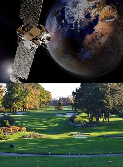
How does it work?

Our advanced satellite technology enables us to "see" beyond the range of colors visible to the human eye. This allows us to detect changes in plant health much earlier than would be possible with the human eye alone. Since healthy plants primarily reflect infrared light, which falls outside of the human visual range, we can use our satellites to detect signs of disease or dryness with great accuracy. Our technology is so precise that even the smallest changes in vegetation health can be identified and analyzed.

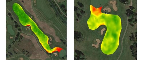
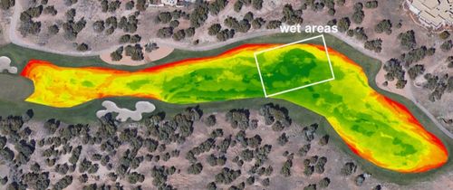
How we monitor grass vitality

Since a healthy plant reflects a special infrared range, with satellite images you will know in advance when your vegetation is affected by disease or dry.
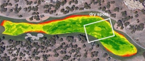
Field Management

With our advanced technology, managing fields becomes much simpler and more efficient. This, in turn, enables you to make more precise and informed decisions regarding irrigation and the allocation of other resources. Our technology empowers you to optimize your agricultural practices and achieve better results.

Why Satellites

One significant advantage of using satellites for data collection, as opposed to drones or other technologies, is the ability to obtain automated images and access data from past years. This feature allows for a comprehensive overview of the entire golf course, including vegetation condition and water saturation levels, and enables the detection of any changes over time. This information is vital for implementing precise measures and optimizing maintenance practices to ensure the best possible course conditions.

Shape Image
Shape Image
Shape Image
Shape Image
Shape Image
Shape Image

Take a look!

These images show how Las Campanas (New Mexico) had dry spots on the #7 Sun Rise Course fairway in 2020. In 2021, the management installed an additional sprinkler that filled the course with water. You might even see the sprinkler circle.

However, you can visualize the data using our platform to make more precise decisions.

Optimize irrigation

Improve the use of fertilizers

Support in communication

with members, owners, and authorities

Saving resources

(Water, labor, etc.)

Our Benefits

We deliver satellite-based vegetation health analysis and soil moisture measurement for your golf course in high resolution and frequency.

User Friendly

Data from space right to your computer, no processing required.

Monitoring

Automatic monitoring of your turf health, if desired with notifications.

Quality

Better turf quality attracts more golfers.

Retrospective

Look into the past with data reaching back to 2018.

Data

Approx 50,000 measurement points on an average 18-hole golf course.

Savings

Save costs by a better use of resources.

FAQ

Frequently Asked Questions

We get pictures every day, but cloud cover might obscure or block the imagery satellites capture, so it is highly dependent on the area conditions. For most regions you could expect 3-4 usable pictures per week during summer and 5-6 usable pictures per month during winter.

The setup of the course is usually done within 15 working days.

A map that shows the details of the area of interest. For golf courses the map needs to show the elements: Fairways, Tees, Greens, Water Hazards and Bunkers, as well as other elements e.g., Driving Range, Practice grounds. If you do not have a map, we can help you to create one.

The system is entirely cloud based, so it runs on any internet connected smartphone, tablet or computer. For a better overview we recommend a devices with a larger screen.

Currently not, we purchase the satellite data from a third party. But we dare to dream big and let’s see what the future holds ;-).

No, because the resolution is 3x3 meters and therefore no persons can be recognized.

No! We only work with remote sensing data, so there will be absolutely no disturbance of your daily operations.

Sure! We are happy to discuss your requirements and provide a detailed quote.